It publishes National Elevation Dataset (NED) in 1 arc second(~30m resolution), 1/3 arc second(~10m resolution) and 1/9 arc second(~3m resolution).
The default file format is ESRI ArcGRID. Several other non-proprietary formats are available. If you don't want to further process the DEM in ArcGIS, GridFloat format is the right choice. GridFloat is "a simple binary raster format (floating point data). There is an accompanying ASCII header file that provides file size information (number of rows and columns). The data are stored in row major order (all the data for row 1, followed by all the data for row 2, etc.)". See National Elevation Data (NED) FAQ.
Follow this tutorial for downloading procedure.
After downloading, unzip the file, .flt is the data for DEM, .hdr is the header ASCII file.
Open header file (.hdr)
ncols 650
nrows 395
xllcorner -86.428333330255
yllcorner 41.639166666159
cellsize 0.00027777777779995
NODATA_value -9999
byteorder LSBFIRST
We can see this DEM has 395 row and 650 col.
In Mathematica:
data30 = Import["ned30.flt", {"Binary", "Real32"}];
(* each row has 650 col. *)
data30 = Partition[data30, 650];
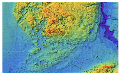
ReliefPlot[data30, DataReversed -> True, ColorFunction -> "Rainbow"]
The following examples show the same area in 1 arc second (30m) and 1/3 arc second (10m) DEMs.
30m


1 comment:
How can the Import statement be altered to read a file that has been written with the MSBFIRST property? (Your files were LSBFIRST)
Post a Comment