Compared to
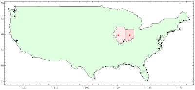
Matlab’s Mapping Toolbox, the mapping ability of Mathematica is rather rudimentary. The overall quality of built-in maps is poor and lack of details. The most annoying problem is that it can't import ESRI shapefile directly. Here is one simple example to show how you can import your own data. Boundaries of Indiana and Illinois in shapefile format are exported to csv format (x,y), then import csv file and display as Polygon. The imported data works well with the built-in map.


2 comments:
The map is great. I was wondering how I could do that. Mind me asking how exactly you made it? Would I have to purchase the ESRI data, if I like to do such maps?
thx
You don't need to purchase any data from ESRI, there are plenty of free GIS data online, go http://nationalatlas.gov/pros.html, you can download Raw data in both ESRI shp file and SDTS format, and SDTS format can be imported into Mathematica directly.
See here for more information
http://reference.wolfram.com/mathematica/ref/format/SDTS.html
Post a Comment